|
|
|||||||||||||||||||||||
|
|
|
|||||||||||||||||||||||
|
VOLGA-DON THE WATERWAY
The city Azov is situated in the south-west of the Rostov region, in the mouth of the river Don on its left bank, in 42 km from Rostov-on-Don. It occupies 67,5 sq. km. It is a city of oblast subordination, independent municipal union, centre of the Azov district. The number of population here is bigger than 82 thousand people.
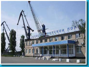
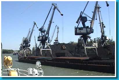
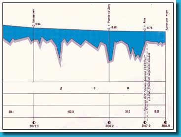
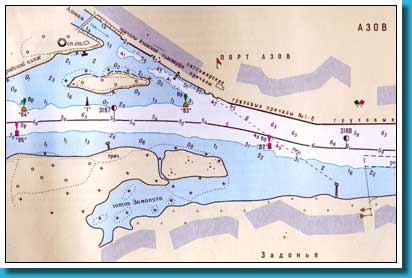
Port Azov  The PORT AZOV is situated on the left bank of the river Don ion a territory about 3167,0-3168,8 km inside Azov. The working area of the port includes a reach of river Don from a village Koluzaevo (3150,6 km) to the mouth, a branch Kalancha (0-14 km) and mouth Svinoe. It is a kind of main gates connecting the Mediterranean sea with internal water system of Russia and the Caspian sea. It allows to deliver goods to the central part of Russia, to the Urals and Central Asia. The PORT AZOV is situated on the left bank of the river Don ion a territory about 3167,0-3168,8 km inside Azov. The working area of the port includes a reach of river Don from a village Koluzaevo (3150,6 km) to the mouth, a branch Kalancha (0-14 km) and mouth Svinoe. It is a kind of main gates connecting the Mediterranean sea with internal water system of Russia and the Caspian sea. It allows to deliver goods to the central part of Russia, to the Urals and Central Asia.The port Azov maschines ships with mineral-building cargos, road metal, coal, ore, lumber and others; carries out local passenger transportation. The port operates amid the year-round navigation, accommodates vessels of "river-sea" type with a lifting capacity up to 5 thousand tons. The port has the international status. There are frontier, customs, sanitary, veterinary and quarantine services on its territory. The total area of the port is more than 24 hectares. Passenger moorings of the port are situated on the territory of 3167,3 km, they are equipped with a vertical wall made of metal rabbet 180 m. long. The ground consists of the sand with silt. Cargo terminals of the port (№ 1 - 10), situated lower than passenger moorings in segment 3164,5-3168,6 km, are equipped with a vertical wall made of metal rabbet. The ground consists of loam and sandy clay. Handlings operations are carried out with the help of 30 bridge cranes with a lifting capacity of 32 tons.
|
|||||||||||||||||||||||
|